
| story by |  |
| photos by | Steven Hertzog |
| OPEN A PDF OF THE ARTICLE |
Douglas County’s famed Santa Fe and Oregon trails were once dotted with towns that were significant yet fleeting during historic times in the United States.
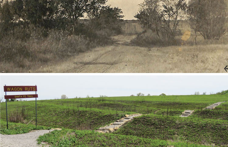
top The Old Santa Fe Trail Courtesy of Baker University-Old Castle Museum
Wagon Ruts Santa Fe Trail Courtesy of Roger Boyd
If St. Louis, with its iconic arch, is forever known in folklore as “The Gateway to the West,” then Kansas, specifically northeast Kansas and more specifically Douglas County, certainly can lay claim to being a “Roadway to the West” for settlers, traders and gold-seekers crossing the ever-expanding country in the 19th century.
Two of the great migratory pathways west of that time—the Santa Fe Trail and Oregon Trail—cross Douglas County from side to side, east to west, west to east. These two “national highways,” before highways existed, actually met just to the south and east of the county near what is today Gardner before splitting westward. The Oregon Trail, first traveled by a party of settlers led by William Sublette in 1830, veered diagonally northwest, crossing just east of Eudora and heading up near Lecompton. The Santa Fe Trail, first traversed by Coronado and Spanish explorers in the 1500s but first traveled on by American explorers in 1821 and surveyed in 1825 by the federal government, meandered slightly northwest toward Baldwin City before turning southwest toward its ultimate destination in New Mexico.
The topography of the Kansas plains was open, flatter and more conducive for wagon train travel, and the climate was wet enough, the foliage lush enough, to provide needed water and food for cattle, mules and oxen that drove the wagons. The trails differed in that the Santa Fe Trail eventually became more a transportation route of commerce and exchanging goods. Traders of all things—crops, furs, pelts and leather goods—moved both westward and eastward throughout most of the year, while the Oregon Trail served mainly as a migratory route for settlers looking to stake claims to free land in Oregon, or explorers searching for gold during the California Gold Rush. Movement on the Oregon Trail was nearly completely westward.
The trails became increasingly busy with travelers in the mid-1800s, and as a result, communities began popping up, either as a result of migrants choosing to settle there or as weigh stops to support the restocking of wagons on their long journeys and resting/watering of stock. Some communities grew more than others. Some became officially platted townships and sought-after respites from the trails. Others grew to be no more than mere specks on a map.
Eventually most, if not all, of these communities disappeared or were absorbed into other cities. The trails shifted slightly for various reasons, or the establishment of railroad lines led traffic elsewhere. All that remains today of communities like Big Springs, Hesper, Kanwaka, Palmyra, Stull and Willow Springs are stories and history. And a closer look reveals there is a rich and fascinating history in many of these towns.
It’s a history, according to some, that should never be forgotten.
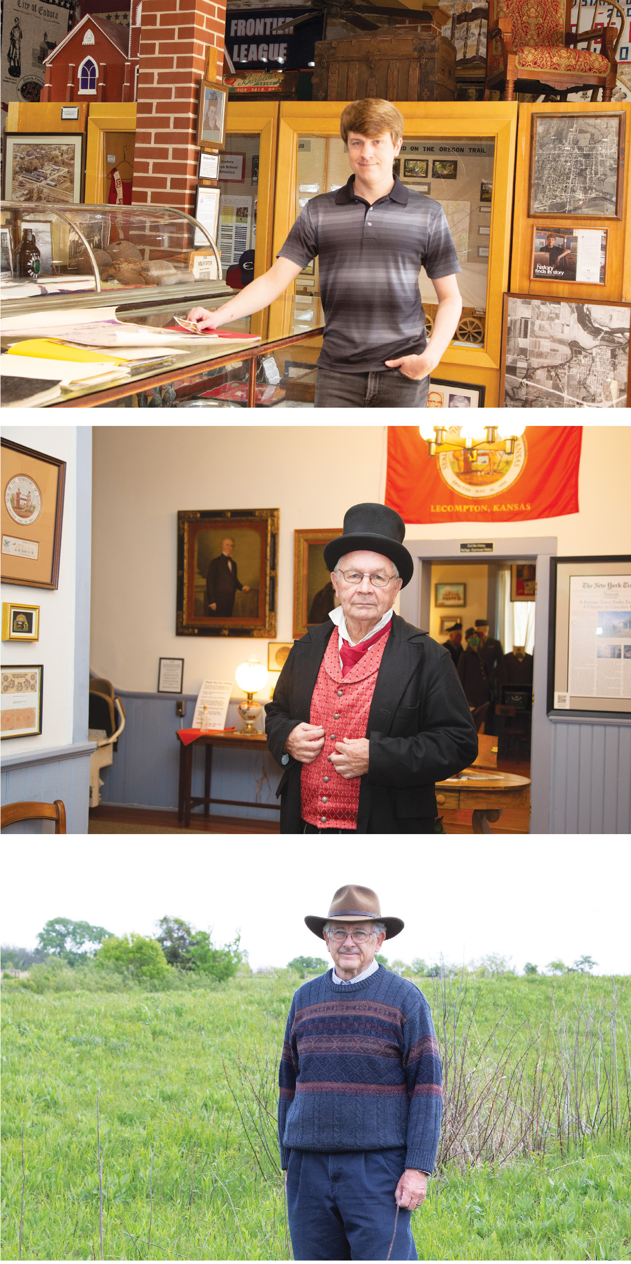
top to bottom Ben Terwilliger Executive Director, Eudora Community Museum; Paul Bahnmaier, Executive Director, Lecompton (Lane University & Territorial Capital Museum); Roger Boyd, Professor Emeritus of Biology, Baker University
“One thing a lot of people don’t realize is that (these trails) helped the United States win the Mexican-American War,” Roger Boyd, president of the Santa Fe Trail Historical Society of Douglas County, says of the armed conflict between the U.S. and Mexico from 1846 to 1848, which came after the U.S. annexed Texas. “Soldiers from Leavenworth, along with Fort Riley and Fort Scott, could travel south to help fight.
“It’s often said that we should learn from history so as not to repeat it,” he continues. “I’m not sure that’s always the case. But I think it’s important for people to know how Kansas came about.”
Much of that story is told through the communities that came and went through the mid-19th to early 20th centuries along the early “superhighways” that were the Oregon and Santa Fe trails.
Free-State Strongholds
One of the most prominent townships to spring up along the Oregon Trail in the county was Big Springs, which was a few miles west of where Lecompton sits today, equally 12 miles from Lawrence and Topeka.
An article in a Lecompton newsletter from 1993 states: “Land of buried treasure, of never frozen springs, of boundless breathtaking landscapes, womb of prohibition and free-state politics—weird as it sounds, that description fits Big Springs.”
Big Springs was three days travel from Westport, Missouri, a major trading post in the mid-1800s, and was an important watering stop before crossing the Kansas River heading west. Kansas became a territory in 1854, and in the fall of that year, William Harper and John Chamberlain took up roots and started Big Springs.
What the town is most famous for is on Sept. 5, 1855, in a barn, part of which still stands today and is believed to be the oldest building in the state, the first-ever convention of the Free-State Party commenced. Attendees drew up articles and bylaws, and the whole free-state movement, which eventually sparked the Civil War, was born. It’s said that the Free State Convention was the beginning of the free-state movement.
In addition to making the territory free of slavery, the people of Big Springs and the surrounding areas also were big promotors of prohibition.
There also were some legends surrounding the town that never materialized.
“It was rumored that someone stashed a bunch of gold around there,” says Paul Bahnmaier, president of the Lecompton Historical Society. “But none was ever found.”
Big Springs continued as a vibrant township through the first half of the 20th century. In 1932, it had the largest enrollment for a one-room schoolhouse (53) in the state. But the Santa Fe railroad bypassed the town in the 1890s and located close to the Kansas River. After 1915, when cars and trucks became available, town trade was lost. Then the installation of the Kansas Turnpike destroyed the spring that gave Big Springs its name.
Bahnmaier explains that today, only one business remains: The Tool Barn. There are about six houses, and of the three churches that used to congregate there, only the United Methodist church remains.
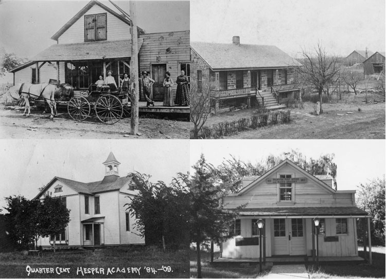
Clockwise from top left: Louk Store in Stull Courtesy Wakarusa River Valley Heritage Museum; Stonehurst Farm, Hesper Courtesy Eudora Community Museum; Palmyra Post Office Courtesy of Baker University Old Castle Museum; Hesper Academy Courtesy Eudora Community Museum
Brief Boroughs
The town of Stull, originally named Deer Creek, was founded by six families of German immigrants in 1857. But the town’s post office closed in 1903, and today, only a couple churches and homes remain. The Battle of Fort Titus, in which three were killed and 14 wounded, occurred about 1½ miles south of Lecompton and north of the Oregon Trail.
Kanwaka was nine square miles between the Kansas and Wakarusa rivers and originally settled by John Wakefield of Iowa in 1854. Wakefield went on to become a preeminent judge in the area, and Wakefield Tavern, built in 1857, served as a gathering place for travelers from throughout the country. A spring on the property still serves as a water source for cattle today.
The Oregon Trail entered Douglas County one mile east of Hesper, a community founded in 1858 by Quakers. Unlike the Free State party, which wanted to keep slavery out of the area, the Quakers were abolitionists.
“They were passionate about making Kansas a free state,” says Ben Terwilliger, executive director of the Eudora Area Historical Society.
The Quakers established the Hesper Academy, the first high school in the area, in the 1800s. A Quaker church still operates in the area to this day, and there are still a few houses, but not much else.
Hesper was home to some prominent Kansans, including Walter Stubbs, who was governor of the state from 1909 to 1913; John Outland, a college football Hall of Famer who has a trophy in his name given annually to college football’s best interior lineman; and James Davis, who established Friends University, in Wichita.
Sparks of Civil War
If Big Springs and surrounding towns off the Oregon Trail can be considered the birth of the free-state movement, then the areas off the Santa Fe Trail to the south can be considered the birth of the Civil War.
It was on June 2, 1856, in an area three miles east of Baldwin City that the Battle of Black Jack took place between small forces of men led by free-state protagonist John Brown and proslavery militiaman Henry Pate. No one was killed during the daylong battle, probably more accurately a skirmish. But many historical accounts refer to the Battle of Black Jack as the beginning of armed conflict that led to the Civil War, which didn’t officially begin for nearly five more years (April 12, 1861).
Today, there is a state park near the Black Jack battleground, off U.S. Highway 56, and visitors are welcome to walk out into a field where they can see large wagon ruts created by 60 years of heavy travel on the Santa Fe Trail.
Also near that area, the township of Palmyra was founded in 1855 at the north edge of what today is Baldwin City. Palmyra offered services including a harness shop, wagon repair shop, three blacksmiths, drug, grocery and dry goods stores, a hotel, a lawyer, two doctors and a tavern.
Palmyra merged with Baldwin City in 1863, but today, the Palmyra Well, a main source of water for the area in the 19th century, still sits just to the east of what is now Baldwin High School.
Also visible from Black Jack State Park is what was known as The Narrows, a ridge forming the divide between the Kansas and Marais des Cygnes rivers, which offered wagons smoother, dryer passage than the creeks to either side. It ran 12 miles between Black Jack and Willow Springs.
Willow Springs was established in 1855, although it was called Davis until 1861, and was a welcomed watering hole, especially for military marching south. The Fort Leavenworth military road joined the Santa Fe Trail just to the east.
Brooklyn also was settled in 1855 and incorporated in 1858, but all but the town’s saloon and general store were destroyed by William Quantrill’s raiders as they retreated from burning down Lawrence in August 1863.
Blue Jacket Crossing was a stop where crossing ramps were cut into the juncture of the Wakarusa and Little Wakarusa rivers, but it became obsolete in 1854 when Blanton’s Bridge was built five miles farther up the Wakarusa. The Hickory Point Community was a loosely defined area from Signal Hill to the east and to almost Brooklyn to the west, stretching along The Narrows. A property dispute ended in proslavery advocate Franklin Coleman murdering free-stater Charles Dow and leaving his body on the Santa Fe Trail.
Finally, Simmons House, built in 1870, was the last stagecoach stop on the Santa Fe Trail until Council Grove, more than 50 miles away. After Council Grove, settlers were forced to fend for themselves the rest of the way west.
“All of this is an extremely important part of history,” Santa Fe Trail Historical Society president Boyd says. “We don’t use the term ‘celebrate’ but ‘commemorate.’ We have to remember that the Indians were pushed out. It marked the demise of many Native American tribes in this area.
“But we should celebrate for all the international commerce that moved along these trails,” he continues. “It was a very important part of the development of this country.”
![]()


